Ft. Buhlow DGC Flooding page.
At
the Red River gauge at Alexandria, the pertinent height for flooding at
Buhlow is 23' with the following tentative reference numbers:
23' Water starts to come out of the ditch in front of the P16 tee box.
24'
P16 is mostly unplayable and water is moving out into the P17 fairway and around the ramps on te bridge near P15.
25'
Water is
behind the P9 basket, around the G15 and G16 baskets and over the
G16 tee box. 18 is playable with water to the right. The P17 tee
is surrounded but still dry.
26' P9, P15, P16, P17, P18, G3, G13, G15 and G16 are unplayable.
26.5' This is the approzimate height of the bottom of basket on the P16 target.
27'
Top of the road at its low point where the ditch crosses the road between P16 basket and G16 tee. P7,
G9, G10, G11 and G12 become unplayable.
28'
P1-6 and most of Gold now unplayable and access to Disc Golf
Parking lot likely shut down. Few holes accessible.
30' Creeks at Kees Park start backing up.
RED RIVER LEVELS & FORECASTS
Red River at
Alexandria (Normal Pool at 20')
Red River at Grand Ecore
(Natchitoches) (~1 day)


Red
River at Coushatta
(~2 days)
Red River at
Shreveport (3 days)


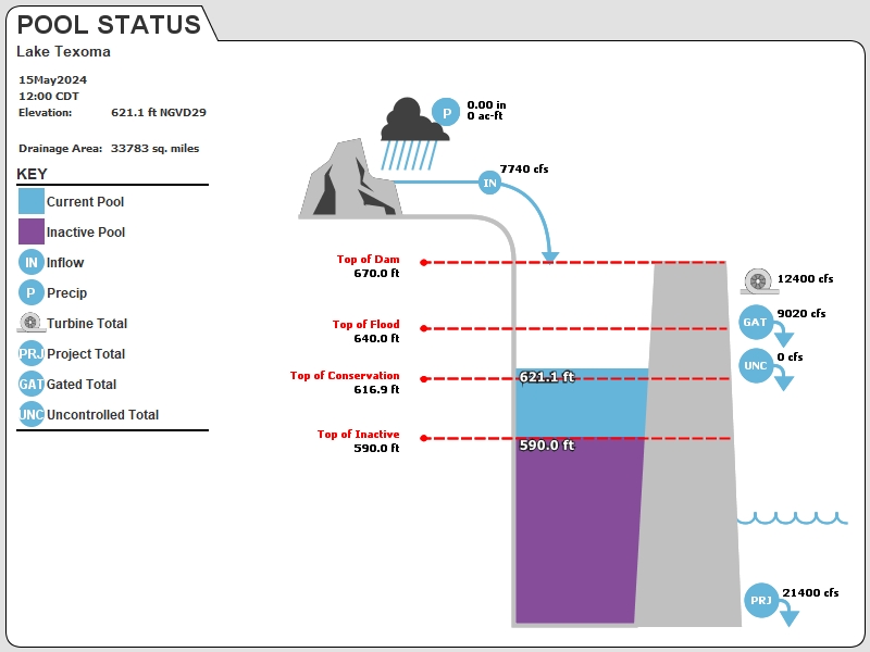
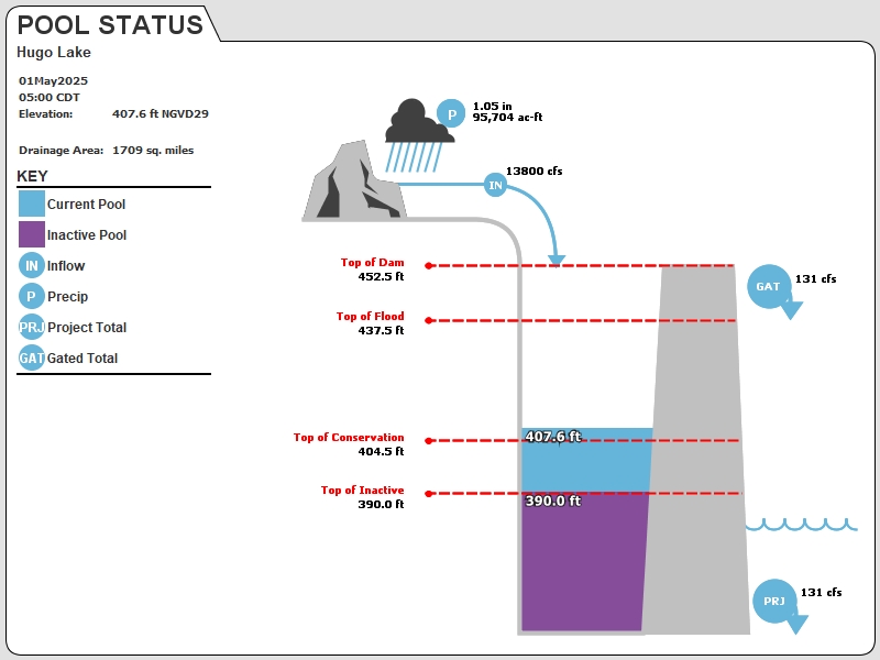
CONDITION OF PERTINENT LAKES
There
are five main lakes that contribute to the Red River's flow. The most
important is Lake Texoma which is a reservoir of the Red River,
followed by Millwood, Hugo, Wright Patman and Caddo. The amount of
water released from those lakes accounts for about 3/4 of the Red River
Flow at Alexandria during most flooding events. The following is the
release information from those lakes.
Texoma
Hugo
Millwood (Normal Pool Level is 259.2')
The following tailwater (FT-MSL) numbers are approximations subject to change (and may affected by RR water level):
229 1,000 cfs
232
4,000 cfs
237'
9,000 cfs
240' 14,000 cfs
243' 18,000 cfs
245' 20,000 cfs
252' 25,000 cfs

Wright Patman
Caddo

Other, less important lakes and tributaries are Bistineau, Pat Mayse, Bayou Pierre and Black Lake.
Flooding that does not involve Texoma, Hugo, Millwood or some
combination of those three will typically not last more than a couple
of weeks.
To check condition further upstream of the five primary lakes, check the reservoirs and rivers upstream from them.
Texoma collects runoff from Northeast New Mexico, South Central Oklahoma and a wide swath of Northwest Texas and the Texas panhandle.
Hugo collects runoff from South Central Oklahoma, before emptying into the Red River east of Texoma.
Millwood
is a reservoir of the Little River in Southwest Arkansas and collects
runoff from Southeast Oklahoma and the Oklahoma/Arkansas border area
including Broken Bow and Pine Creek lakes.
Wright-Patman
is the water supply for Texarkana and drains the extreme northeast
corner of Texas. Its contribution to the Red River during flooding
remains constant at about 10,000 cfs.
Caddo Lake
is an impoundment of Cypress Bayou which collects runoff from
Lakes Cypress Springs, Monticello, Bob Sandlin, Lake O' The Pines and
Ellision Creek Reservoir and then empties into the Red River just north
of Shreveport.
Bistineau
is an impoundment of Bayou Dorcheat which collects water from an area
between Shreveport and Minden and the Arkansas border north of that
area.
Pat Mayse is a small lake in Northeast Texas that drains directly into the Red.
Bayou Pierre collects water between the Red River and Sabine to the south of Shreveport and empties into the Red south of Natchitoches.
Black Lake
collects water from an area south of Coushatta and to the east of the
Red River. It empties into Black Lake Bayou which, in turn, empties
into the Red north of Natchitoches.
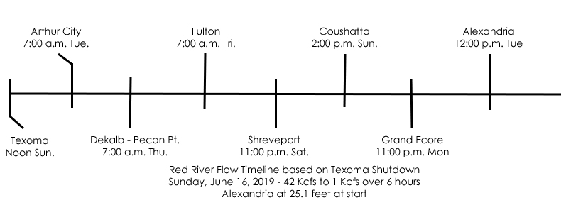
TIMELINE FOR CHANGES
The
following graphic shows the predicted dates for an abrupt, 40,000 cfs
flow reduction from Texoma to move down river. The reliability
deteriorates the further downriver the trough moves due to flattening
out.